

Introduction
The fiercest storm on Earth this year is now smashing across the northern Philippines. Super Typhoon Ragasa, or Typhoon Nando as the locals call it, turned from a strong tropical storm into a monster in just hours over the Philippine Sea. Its winds now top 267 kilometers per hour (165 miles per hour), ranking it a Category 5 system, the highest level. Ragasa is a serious danger to millions in Southeast Asia.
The name “Ragasa” means “rapid” in Filipino, and this storm is living up to it. Typhoon Nando is now racing toward the northern Philippines, and coastal areas from Hong Kong to Taiwan and southern China are rushing to prepare. This post will explain the typhoon’s destructive track, the heroic preparations happening on the ground, and the worrisome link between storms like this and our warming planet.
The Wrath of Ragasa: Path and Intensity
Super Typhoon Ragasa’s blazing rise is gripping meteorologists around the globe. In a few spectacular hours, it went through a phase called rapid intensification, ballooning into a sprawling, crashing storm. That speed-up was fed by unusually warm sea surface temperatures, the kind of ocean energy storms like Ragasa suck up to grow into giants.
The storm is undergoing an eyewall replacement cycle, which is a fancy way of saying a new ring of thunderstorms is growing farther out from the center. This ring eventually takes over the smaller, older eyewall. When the change is done, the storm is a bit bigger, the wind reach is wider, and the center seems to pulse with more punch. Meteorologists worry that we’re seeing this rapid intensification more often these days because water temperatures are climbing worldwide.
On Monday, September 22, Ragasa was still more than 1,000 kilometers east-southeast of Hong Kong, cruising west at about 23 kilometers per hour (or 14 miles per hour). Forecast maps show it swinging to graze the Babuyan Islands and the Batanes way up in the northern Philippines. After that, it should keep eyeing the busy coastlines of Southern China and Vietnam.
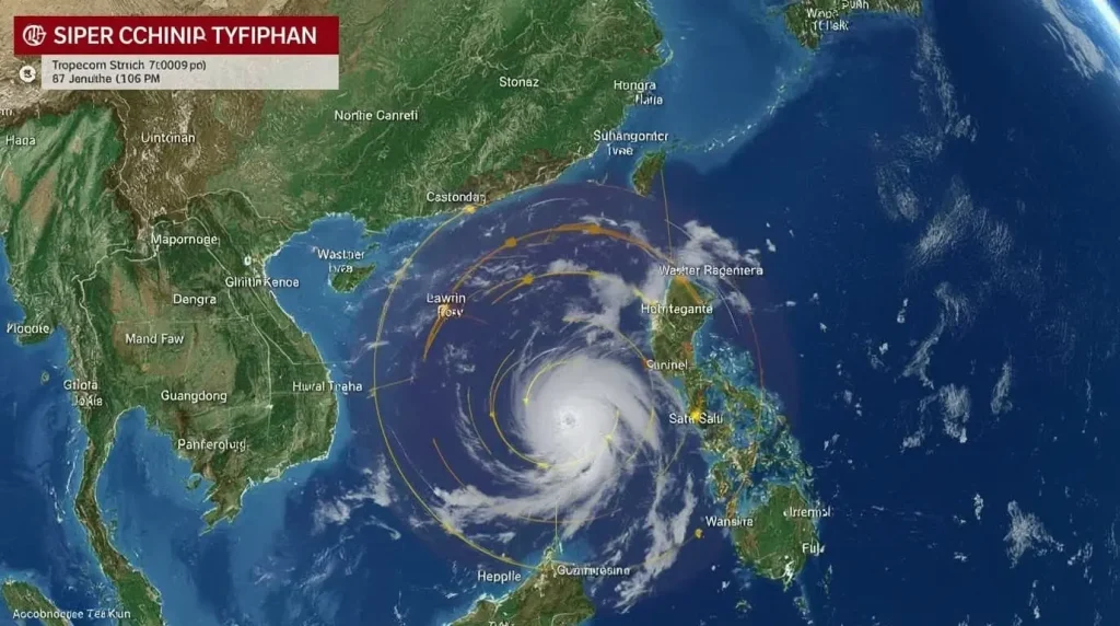
Table: Super Typhoon Ragasa Key Metrics (as of Sept 22, 2025)
| Feature | Measurement |
|---|---|
| Maximum Sustained Winds | 267 kph (165 mph) |
| Gusts | Over 315 kph (195 mph) |
| Movement | West at 22-23 kph |
| Central Pressure | ~900 hPa |
| Saffir-Simpson Scale | Category 5 Equivalent |
Impact on the Philippines: Evacuations and Disruption
The Philippines is bracing for Super Typhoon Ragasa, and the storm is already hitting its peak. PAGASA, the national weather agency, has raised Signal No. 5 for the Babuyan Islands. This is the strongest warning, declaring “potentially very destructive” winds and storm surges that may top 3 meters (10 feet).
To limit casualties, government teams have already moved more than 10,000 residents to safer sites and emergency shelters, focusing on coastal and low-lying communities. “Homes and property can be rebuilt, but lives lost can never be replaced,” the Department of the Interior and Local Government stressed. People are advised to stay in safe places and to follow all storm warning updates closely.

The social and economic shock is deep. Work and classes are on hold all over northern Luzon, and the shuttered aisles now include the capital, Metro Manila. In 29 provinces, agencies and local governments packed up. Airlines canceled a wave of domestic flights, and ferry services at the main ports stopped, leaving thousands of travelers on the docks. In northern Cagayan, hospitals have gone to standby mode and families are lining the aisles at grocery stores to stock up on the essentials they can still find.
Wind is just one part of the danger. Ragasa’s massive size is primed to release a violent wall of rainfall, with forecasts suggesting more than 400 millimeters—15 inches—over a handful of northern Luzon areas. That sets the stage for non-stop floods and deadly landslides, especially in the steep provinces already cut and scarred by the long monsoon that just flooded hundreds of villages.
Alert is already running wild in Hong Kong, Taiwan, and south China. Ragasa is barreling, eyes on the northern Luzon water, and will soon reach Taiwan Strait ways. Tens of millions more folks are now scanning the news, ears tuned for sirens and text alerts.
Hong Kong is ramping up storm prep as Typhoon Haikui approaches. The Hong Kong Observatory (HKO) sounded the alarm on Monday, first with the T1 standby signal at 12:20 PM. The Observatory aims to upgrade that to the T3 strong wind signal by 9:40 PM. More critically, the HKO is considering a T8 signal, which closes businesses and schools, between 1 PM and 4 PM on Tuesday.
Authorities want residents to act as if the T8 signal is already in effect. The Observatory forecasts a rapid worsening of conditions on Tuesday, with peak danger expected on Wednesday. The HKO reports that winds will reach gale-to-storm force inland and peak at hurricane strength offshore and on elevated terrain. Seas will be extremely rough, with surging swells. The storm is also expected to create a formidable surge of about 2.0 meters, pushing water in some coastal areas to 3.5 to 4.0 meters above the chart datum. Those levels mimic the damaging surges seen in the deadly Typhoon Hato (2017) and Typhoon Mangkhut (2018) events.
Hong Kong International Airport is moving toward a historic step: it may shut down all passenger flights for 36 hours, from 6 p.m. Tuesday to 6 a.m. Thursday. Officials expect soaring hurricane-force winds that would make flying simply too dangerous. If the plan gets the final go-ahead, it will be the longest passenger Ops stand-down the airport has seen in a long time. Ahead of the closing window, airlines like Cathay Pacific and Qantas have rolled out travel waivers and are telling anyone flying to expect major delays and cancellations.
Taiwan may avoid a direct hit from Typhoon Ragasa, still, the island is taking no chances. Authorities have already posted land and sea warnings. The eastern half of Taiwan will be soaked from downpours that raise the risk of flooding and landslides, particularly in the mountains. So far, nearly 300 residents in Hualien County have been placed on standby for possible evacuation. Passenger ferry service is off the timetable, and several scenic trails in southern and eastern Taiwan are now on the closure list.
Meanwhile, Guangdong province has issued a blunt alert, urging residents to brace for a possible “catastrophic” large-scale disaster. Forecasts indicate that the province will face heavy rainfall and brutal winds starting on Tuesday. Emergency services are already mobilizing to deal with the storm.
The Climate Change Connection: Cramming Fuel into Every Storm
Super Typhoon Ragasa isn’t just another storm; it fits into a long line of ever-stronger tropical cyclones. The western Pacific already has a reputation for hectic weather, but scientists agree that fossil fuels and greenhouse gases are making these storms function like performance cars on nitrous.
The science works like this: as sea water warms, storms break into overdrive. We’ve seen global ocean temps already flashing red on charts for years, and that trapped heat becomes a turbocharger for typhoons. The storms are now increasingly likely to mash the gas pedal, ramping up wind speeds in record time. Ragasa demonstrated this, surprising even the most seasoned forecasters.
Hong Kong Observatory has been ringing the alarm, stating that record-breaking rainfall is now a new normal, not a surprise. The facility’s hourly record, once “rebuffed every couple of decades,” has been reset multiple times just in the past few years. An already formidable storm like Ragasa now has the added threat of unleashing a fire hose of rainfall, making landslides, flash floods, and widespread destruction even more inevitable.

The growing strength of storms like Super Typhoon Ragasa, along with similar systems such as Hurricane Erin, highlights how climate change is visibly twisting weather patterns and endangering human safety. These intensifying storms are no longer far-off theories; they are current realities that demand our attention and action.
Conclusion: Nature’s Strength We Cannot Ignore
Super Typhoon Ragasa serves as a clear warning about how powerful storms can be and how even the most prepared areas can be caught off-guard. So far the strongest storm of the year, Ragasa hit the Philippines hard, then set its sights on Hong Kong and Southern China, reminding us that extreme weather will continue and may even worsen.
Large evacuations across the Philippines, the possible record-long airport closure in Hong Kong, and emergency alerts across nearby countries demonstrate how quickly the region must react to try to save lives. The name Ragasa—which means rapid movement in Filipino—will be remembered not just as a label, but as a record of speed, strength, and the vital need for communities to remain alert in the face of nature’s overwhelming force.
Ragasa is another reminder that super typhoons are changing how they form—and they are forming quicker than ever. Warmer oceans give these storms extra energy, so they spin up and grow stronger before we have a chance to fully prepare. If we don’t build stronger homes, schools, and hospitals in storm zones and cause even less pollution, storms like Ragasa could become the “new normal.” The path Ragasa took is more than a map line: it’s a lesson in survival, a reminder to prepare now, and a clear call to the whole world to cut climate-damaging emissions.
Source: https://edition.cnn.com/2025/09/22/asia/super-typhoon-ragasa-philippines-hong-kong-intl-hnk
For more incredible stories of everyday news, return to our homepage.